Wowww it's been so long since I've written on here, but I'm thinking about giving it another go and sharing my adventures yet again! Thanks to COVID, my adventures have been domestic, but I'm living in Colorado now and there are innumerable adventures to be had! Mostly I've been having peak adventures. I'm working on my Masters degree in Environmental Management at Western Colorado University in Gunnison. It's been interesting. But mostly, I'm happy that it brought me to Colorado!
I moved out there last summer. I had a fellowship with the Forest Service, creating an Invasive Species Management Plan for the Fossil Ridge Wilderness near Gunnison. So basically, I was paid by the USFS to hike around on all the trails in the Fossil Ridge last summer looking for invasives. I only found one! So that's nice. Anyway, I had a great summer, but I didn't get up on many peaks because I was busy hiking there. So I made it up six 14ers last summer.
This summer, on May 18th, I summited Mt. Whitney, the highest peak in the continental U.S! A few of my pals came, and my friend Patrick made us workouts that we started doing to prep for the hike. It was a great time. We hiked up on the 17th, made camp, and tried to prep for the next day. The snow was melted out more than I hoped, so there was no need for crampons. We did wear micro spikes and mountaineering boots though, and of course helmets! I was glad there was still some snow.


 I’m going to talk about Lake City 14ers first. This group of peaks are some of the most accessible from Gunnison and they’re all pretty mild in terms of technicality. There are five 14ers in this area. They are, Uncompahgre, Red Cloud and Sunshine, Handies, and Wetterhorn. Most of these are beautiful and offer really incredible views and fairly easy hikes. Three of them can even be accessed from the same trailhead.
  If you’re interested in a 2fer with a very easy ridge, Red Cloud (14,034’) and Sunshine (14,001’) are perfect peaks for that. Meaning after you gain the elevation to Red Cloud, you follow a very easy saddle to the summit of Sunshine. They were my first 14ers!


Wetterhorn (14,015’) is a bit more of a challenge. The classic route up Wetterhorn is only 7 miles roundtrip up the SE Ridge, but it is Class 3. The first several miles are very mellow before the trail turns to rock. Once you reach the top of the ridge, you have some exposed rock scrambling to do before you reach the summit. This is the Class 3 section and it is a ton of fun! We tacked on Matterhorn (13,590’) for an added bonus, which can be done by descending Wetterhorn until you can cross a big grassy slope on your left and following it up to reach a short Class 3 section, and the summit. 


On the Matterhorn summit with Wetterhorn in the background
Class 3 and higher is my favorite hiking by far! Because it's just as much climbing as it is hiking and it is a grand adventure!!


The traverse did take at least two hours, if I recall correctly, but clambering on boulders is pretty fun for me (at least it was for the first hour). I recommend saving the AllTrails route to see the basic trail to follow for this one. Then it's up to the Columbia summit, where I was cheered for because of the traverse's bas reputation. I typically always recommend having trekking poles, but I especially recommend them for this route.


 This is BLM land and there are tons of great campsites here for before and/or after your hike.


If you want to hike one of the least popular 14ers, the loner peak, head to San Luis Peak (14,014’). The standard route is Class 1 and around 14 miles. I don’t know why this guy is so unpopular, it might be because it’s so outof the way, or because the hike is pretty uneventful, but whatever the reason, I appreciated the seclusion of this hike. Instead of a sizeable parking lot like
 virtually all other 14ers I’ve been to, this trailhead is just a pull-off on the side of the road called Stewart Creek. It’s a decent hike that meanders through the woods and valley before gaining the ridge and crossing very easy rock to the summit. The sun rose just before I gained the ridge and it was most certainly a beauty.
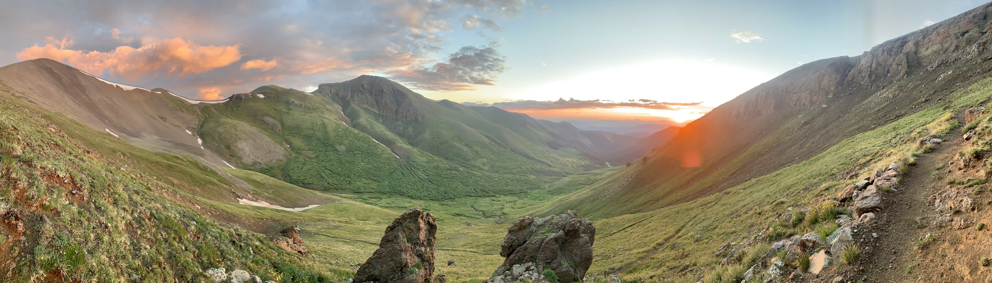

Now we get to the fun part. The spicy part. I have yet to complete ALL of the spicy 14ers, but I have completed the two hardest and one of the four “grand traverses of Colorado”. Those being Capitol (14,130’) and Little Bear (14,037’) and the Crestone Traverse between Crestone Peak (14, 294’) and Crestone Needle (14,197’). Please read all about the routes on 14ers.com and AllTrails (if applicable) before taking on any of these and don’t forget a helmet.

 We were exhausted at summit and had to prep ourselves for the long, grueling way back down, but the views were phenomenal! We did this hike on 4th of July weekend 2021 and there was enough snow to do some glissading on the way down. There weren’t massive crowds like you’d expect on a 14er on this weekend because the daunting task of the Knife’s Edge and the grueling miles before and after itkeeps most people away. July, but still enough snow to do some glissading on the descent!!

But to reach summit, you’ll need to pass the fear-conjuring Hourglass. To put your mind at ease, the Hourglass was the most fun I’d had on a 14er (up until that point). It’s true that you need to be very wary of rock fall and people above you, but for me the worst part was the mountain of choss that must first be ascended. This was the loosest vertical hill I’ve ascended, or descended, and it majorly sucked both ways. So be very careful in this section! The Hourglass itself was really fun climbing! The down climb is a little sketchy, but there’s a fixed rope there to help with the descent.


 Now let’s talk about the most fun I've had on a 14er to date! The Crestone traverse is renowned as one of the four iconic traverses of Colorado 14ers and rightfully so. First day, you want to hike up to South Colony Lakes. We hiked in, found a campsite, and hiked Humboldt peak (14,064’). Humboldt is super mellow, and we still had most the day to kill. I was anxious about the traverse that would come the next day! The Crestone traverse is rated Class 5 because of one move that is rated a 5.2.
ous. But when I saw the wall, I was pleasantly surprised.
We got a magnificent sunrise on the way up! The summit was pretty cold, but it was sunny and glorious! The hike was technically very easy and if done in two days like we did, its very breezy. I'm super proud to have made it up Whitney's summit. It also got me really keen on hiking peaks!
In the time between the beginning of July and the middle of September, I went up twenty-six 14ers, 15+ 13ers, and plenty of other peaks! My current peak streak is 16 week(end)s in a row that started with a failed attempt on Wetterhorn. After I failed on Wetternhorn, my weekends went Capitol (the hardest 14er); MOB (Missouri, Oxford, Belford) in a day; San Luis Peak; Little Bear, Blanca and Ellingwood Point, 7 13ers: Jones, American, Half, I forget the others; Conundrum and Castle; Harvard and Columbia; Handies with the fam; La Plata and Colorado's highest peak Mt. Elbert; Crestone Peak, Needle and traverse and since it was a three day weekend, I also did Mt. Democrat, Cameron, Lincoln and Bross (making it a seven 14er weekend); Wetterhorn- finally a success, and 13er Matterhorn, Huron and Antero; Wheeler Peak (NM's highpoint) and Humboldt Peak (AZ's highpoint); and finally Archer Peak in Washington, just so I wouldn't ruin my peak streak!
The most important thing about hiking is being prepared, so know what you’re getting yourself into. Know the route, know the terrain. 14ers.com is a great resource for all your 14er hiking needs! It also has a feature where you can add tick marks to the peaks you’ve done. This is a useful tool, except making a list has made me even more determined. I also frequently back up my knowledge by using AllTrails and bringing that knowledge along too.
14er difficulty changes depending on the time of year, weather conditions, your fitness level and technical experience. Many of the routes are Class 1, meaning they do not require technical skills, just good fitness. Handies (14,048’), in the San Juans, is rated as one of the easiest 14ers. It’s Class 1 and accessible from Lake City. The 14ers that are accessible from this area are some of the closest ones to us in Gunnison and range in difficulty.
Uncompahgre (14,309’), is a very easy Class 2 hike that delivered one of the best sunrises I have ever seen in my life.
The total hike is about 7.5 miles. Uncompahgre for me was a classic example of the weather changing rapidly in the mountains; what started off as a sunny and clear day, turned into hail and snow at the summit.
Next I want to talk about the Collegiates. They are an incredible range of peaks in between here and Buena Vista and are accessible after crossing Monarch and heading north. The northernmost peaks are Missouri (14,067’), Oxford (14,153’) and Belford (14,197’), then Huron (14,003’), Harvard (14,420’) and Columbia (14,073’), Yale (14,196’), and ending with Princeton (14,197’). I can happily say I’ve completed all the Collegiates! There are some really wonderful peaks in this area with some cool combo routes.
Oxford and Belford can be done in a day, and if you’re feeling really wild, Missouri, Oxford and Belford (or MOB as we call it) can be done in one looong day. Which of course, is what I did. (Look on AllTrails for the route description). MOBbing in a day means over 16 miles and over 7,000ft of gain. I recommend doing the loop counterclockwise and starting with Missouri. This is a long day with a lot of miles and a lot of gain. All three of these peaks can be hiked separately and unless you’re in very good shape for climbing, probably should be done that way. I did them all together, and it was a fantastically exhausting day.
Harvard and Columbia can be done as a combo route. Be warned, everything you read will tell you that this traverse SUCKS. I personally didn’t think it was that bad. It was one of the longest traverses I’ve experienced. The boulder fields took forever to cross, way longer than one might expect, and it gets tedious after awhile. The total hike is over 16 miles and 6,000’ of elevation gain. It’s not easy, but it’s not the worst thing ever. I started early and made it to the Harvard summit for a brilliantly orange, but smoky, sunrise.
Yale and Princeton are both great hikes that cannot be combined with any other 14er and are each done separately. Great peaks though! They are beautiful and closer to Gunnison than the other Collegiates. Yale was the first Collegiate I hiked and one of my first 14ers; I loved the forested area below treeline, which got me hooked on hiking in this range. They are both Class 2, and roundtrip Yale is 9.5 miles while Princeton is only 6.5. Both are decently mellow and fun hikes. Everyone drives up the 4x4 road to Princeton, that road is long and if you don’t drive it, it doubles the length of the hike.
The Collegiates are a great place to hike that’s pretty easy to access from Gunnison. The peaks can all be done individually, or some combinations exist for those of us who have yet to master the art of sitting still. And, maybe my parents are proud that I finally joined the Ivy League.
Probably the most accessible 14ers from Gunnison are Shavano (14,229’) and Tabeguache (14,155’). If you leave town and head east towards Monarch Pass, before you hit Salida you’ll find the road that will take you to these two.
These two peaks are connected by a saddle, so you’ll hit Shavano and if you feel like continuing, you drop down in the saddle and then back up to summit Tabeguache. Roundtrip the total hike is approximately 11 miles and rated Class 2 due to some looser chossy sections. This is a great hike but if you’re going to do both peaks, be warned, you lose about 600’ of elevation before reaching the saddle and needing to gain it back for the next summit. Doing Shavano by itself is still 9 miles, so tacking on the extra peak for only two extra miles is worth it if you’re feeling good! This was one of my 14ers last summer and it's awesome to think about how far I've come since that time! I am on track to becoming a professional mountain goat for sure.
If you continue driving past Monarch, turn left onto Hwy 285, before you hit Buena Vista you’ll turn left and find yourself at Antero’s ungodly 4x4 road. The drive here takes a little under 2 hours. (You can use AllTrails to get directions to right here). I’ve taken the Hobo Rocket (my 4Runner) on some pretty gnarly 4x4 roads. But this. This is different. It’s horrible. If you do not have some crazy lifted beast of an offroading machine, please do not drive this road. It’s not worth it! I drove about 2 miles up before I stopped and hiked the rest of the way. It’s a long hike so I can see the temptation, but you’ve got to do whatever you’re comfortable with.
Antero stands at 14,269 feet tall and is in the Sawatch range. From the lower trailhead, the hike is 15 miles with an elevation gain of somewhere near 5,000. The hike is almost entirely on round rock the size of your fist. These rocks get annoying to walk on after awhile, and they’re particularly slippery on the descent, so watch your step. There will also be OHVs and Jeeps passing you along the trail as these guys can make it almost all the way to the summit. The summit is pretty, but this was not one of my favorite hikes. The end was such a slog, and I kept falling on the smooth stones as I was down climbing. To be fair, I did Huron and Antero in the same day. These two 14ers are not connected by a saddle and I had an hour drive between them. This meant my total day was 20 miles and about 7,500' of elevation gain. And then I went to work after..!
So, Capitol the grand hurrah of all Colorado 14ers. It’s definitely worth the hype! The hike is Class 4, and 17 miles with over 5,000’ of gain. It’s a lot! But the good news is that about 5 miles up the trail are some great campsites by Capitol Lake, and I cannot stress enough that you should camp here and head for summit the next day. This is a long, difficult hike and doing it in two days is definitely preferable. The hike up until this point is Class 1 and very easy, the next half mile or so is some pretty grueling switchbacks, and then the fun begins. Classic rock scrambling here for quite awhile before heading right and gaining the ridge near K2. You can summit K2 if you’re feeling it, otherwise continue on a fairly exposed ridge on Class 2-3 rock before hitting the infamous Knife’s Edge, which is a super exposed section where you’re literally on a small edge. Some people scoot across it on their butts, straddling the edge itself.
After crossing, you continue on class 3-4 rock until the summit. It takes a really long time to move across this rock so give yourself a lot of time for this section.
Little Bear is another great one to make a weekend out of. The hike up to Lake Como is about 5.5 miles, depending on where you park on the 4x4 road. If you start at Lake Como, the hike to Little Bear’s summit is 3.5 miles.
So, we hiked up to Lake Como and summited Little Bear in a day. Another option is to hike in, camp, and hike Little Bear the next day. This was our original plan, but the weather was gnarly and made it impossible to hike up until the following day. The day after Little Bear, we hiked Blanca (14,345’) and Ellingwood Point (14,042’), as these 14ers can be done from Lake Como as well. They are both rated “Difficult Class 2”. They are pretty easy hikes and shorter. There is a traverse between these two peaks, but the wind was so wild at the ridge that we went a little below the true ridge before regaining elevation to the ridge.
Southeast Ridge of Ellingwood Point
There is a traverse from Ellingwood to Lake Como; on 14ers.com it's called the Southeast Ridge. If you do this, please do your research, and I recommend coming up from Lake Como onto the southeast ridge and then heading to Ellingwood. From there, you can take the traverse over to Blanca and make something of a lollipop loop out of it. We did this in reverse, and it was not ideal, so I definitely recommend going this way.
Early early we started out for Crestone Peak. We ascended the red gully and eventually made our way to summit.
We met a few guys along the way, and we all teamed up for the traverse. All of us had the route photos on our phones and were well prepared for the adventure that lay ahead of us. The route wasn’t too hard to follow and consisted of lots of fun Class 3 rock scrambling. A few sections were a little spicy, but not too bad at all. The first ¾ of the traverse are pretty mellow and you get all the really fun stuff at the end, so this is a very committing route. After awhile you reach the 5.2 move. Some people have brought climbing shoes for this part, but it’s one move and over very quickly. We brought climbing shoes since we had heard of others bringing them, but we never ended up using them, so I would save yourself the weight and not bother.
The 5.2 move is pretty simple to get over and once you’ve climbed that, you’re right on to the knife’s edge of this climb.
Once you pass this much shorter knife’s edge, you have a bit of climbing to do before you reach the very infamous Class 4 headwall to the summit. This wall is the heady, exposed crux of the traverse. Everything you read about this wall strikes fear from the “any mistake and you’ll fall to your death” to “there’s no downclimbing and going back, once you’re here, you must go up”. Comments like this got me nervous.
The headwall was a breeze, and super fun! Sure, it's exposed, but I recommend not looking around too much till you reach the top. The holds are super solid, of course you should test them before putting all your weight on one rock, but just be smart and it’s a great time. At the top, you have a short walk and then you’re at the Crestone Needle summit!
You can descend the Class 3 or Class 4 route down the needle and back to the lakes. Upon getting back to the lakes, we packed up our stuff and headed down to the trailhead. Quite possibly the most fun day I’ve had on a 14er, and one of the most fun days I’ve ever had! 
These routes are not for beginners, and they do not lend themselves to solo hiking. I hike by myself a lot, but I try to avoid doing anything Class 3 and up, solo. So find some hiking/climbing friends and work your way up. Look at some of my other articles on easier peaks before making your way to these. Being well prepared sets you up for a successful, amazing day in the mountains.

I have so much more hiking to talk about! Especially since I started my highpoint journey, but more on that later!!
No comments:
Post a Comment